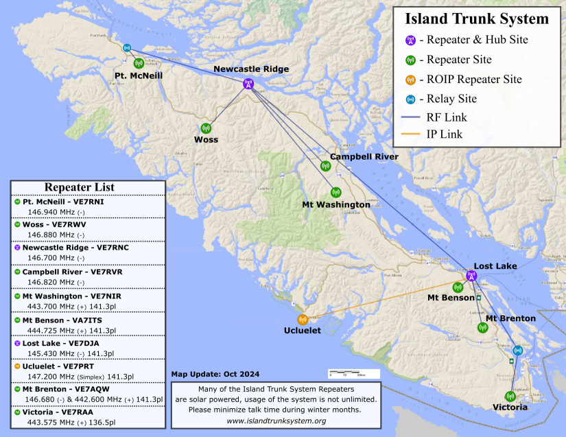
Lost Lake VA7DJA 145.430− 141.3->UHF link->Mt Brenton VE7AQW 146.680− 141.3 442.600+ 141.3
Lost Lake VA7DJA 145.430− 141.3->UHF link->Mt Benson VA7ITS 444.725+ 141.3
Lost Lake VA7DJA 145.430− 141.3->IP link->Ucluelet VE7PRT 147.200 141.3
Lost Lake VA7DJA 145.430− 141.3->RF link->Saltspring Relay
Saltspring Relay->RF link->Victoria VE7RAA 443.575+ 136.5
Newcastle Ridge VE7RNC 146.700− 141.3->220 link->Lost Lake VA7DJA 145.430− 141.3
Newcastle Ridge VE7RNC 146.700− 141.3->UHF link->Mt Washington VE7NIR 443.700+ 141.3
Newcastle Ridge VE7RNC 146.700− 141.3->220 link->Campbell River VE7RVR 146.820− 141.3
Newcastle Ridge VE7RNC 146.700− 141.3->220 link->Woss Lake VE7RWV 146.880−
Newcastle Ridge VE7RNC 146.700− 141.3->220 LINK->Port McNeill Airport Relay
Port McNeill Airport Relay->UHF LINK->Port McNeill VE7RNI 146.940−
Table of Contents
Sunshine Coast Emergency Communications
PDFs To Print
- An up-to-date copy of this page
- BCARCC repeater frequencies for Lower Mainland & Coast and Vancouver Island
and/or this amalgamated spreadsheet list.
Initial Actions in the Event of an Emergency
In the event of a significant emergency affecting communications across the Sunshine Coast, all amateur radio operators should:
- Monitor the VE7RXZ repeater on VHF 147.220 MHz +0.6 T100.0 for traffic or requests for assistance from VE7SCE.
- If VE7RXZ is not operational, monitor 147.220 with 100Hz tone (without any offset) (Net controllers monitor 147.820 for operators that are operating in duplex and let them know to go to simplex on 147.220 T100.0)
- If able, also monitor VE7SCK 442.650 +5.0 T100.0.
- If VE7SCK is not operational, monitor 442.650 with 100Hz tone (without any offset) (Net controllers monitor 447.650 for operators that are operating in duplex and let them know to go to simplex on 442.650 T100.0)
- If able, also monitor simplex VHF: 1: 146.430 MHz, 2: 147.540 MHz, 3: 146.490 MHz, 146.565 MHz for traffic or request for assistance from VE7SCE.
- If able, monitor EMBC HF frequencies for information (see below).
It is unlikely that VE7SCE will use HF for local communications on the Sunshine Coast, however relays may be required for another station on frequency and operators should monitor EMBC or BCPSN HF frequencies if able to do so.
Declaration of State of Emergency by the SCRD EOC
The following will be broadcast from VE7SCE on VE7RXZ 147.220 MHz +0.6 T100.0 and/or on simplex frequencies:
Taking Control of the Net
- ALL STATIONS, ALL STATIONS, ALL STATIONS:
- This is VE7SCE – Sunshine Coast Regional District Emergency Operations Centre, Sechelt, British Columbia.†
- A [LOCAL / REGIONAL / PROVINCIAL] State of Emergency has been declared, I say again:
a [LOCAL / REGIONAL / PROVINCIAL] State of Emergency has been declared. - This frequency is now in use by the SCRD Emergency Operations Centre - VE7SCE - all stations not having emergency traffic are requested to remain clear.
- If you have traffic concerning safety of life or property in the Sunshine Coast Regional District, and you are unable to contact 911, relay your traffic to this station.
- Otherwise, if it is safe to do so, all station operators within the SCRD region are requested to remain monitoring this frequency as your assistance may be requested.
- This is VE7SCE, SCRD EOC Net Control monitoring...
Taking Check ins
- ALL STATIONS, ALL STATIONS, AL STATIONS:
- This is VE7SCE – Sunshine Coast Regional District Emergency Operations Centre, Sechelt, British Columbia.†
- Stations within the SCRD region are requested to check in now with your callsign, name and location.
- Once checked in you must inform SCRD Net Control if you intend to leave the frequency.
- This is VE7SCE standing by ...
† As we share a frequency with W7AVM on Whidbey Island in Washington State, the full SCRD name and location will be used initially to avoid any confusion should our traffic be heard south of the border.
HF Emergency Frequencies
Sources: http://www.percs.bc.ca/ and https://www.rac.ca/ 
| Description | Frequency [MHz] | Mode |
|---|---|---|
| EMBC 80m Primary Night | 3.735 | LSB Phone |
| EMBC 80m Secondary Night | 3.745 | LSB Phone |
| EMBC 40m Primary Day | 7.060 | LSB Phone |
| EMBC 40m Secondary Day | 7.070 | LSB Phone |
| EMBC DATA | 3.613.50 | USB DATA |
| EMBC DATA | 7.089.50 | USB DATA |
| VE7SWF South West EMBC PREOC | 14.135 | USB Phone |
| VE7SWF South West EMBC PREOC | 21.120 | USB Phone |
| VE7KAZ Kamloops EMBC PREOC RMS | 5.371.50 | USB DATA‡ |
| VE7RBH Smithers, BC Winlink RMS | 3.623.50 / 7.063 | USB DATA‡ |
| WASHST 01 Washington State | 3.985 | LSB Phone |
| WASHST 02 Washington State | 3.994 | LSB Phone |
| WASHST 03 Washington State | 7.245 | LSB Phone |
| BCPSN: BC Public Service Net | 3.729 | LSB Phone |
| ALASKA Emergency Net | 14.292 | USB Phone |
| EMCOM A | 3.675 | LSB Phone |
| EMCOM B | 7.135 | LSB Phone |
| EMCOM C | 14.135 | USB Phone |
| EMCOM D | 18.135 | USB Phone |
| EMCOM E | 21.235 | USB Phone |
| EMCOM F | 28.235 | USB Phone |
| OREGON | 3.980 | LSB Phone |
- EMBC: Emergency Management BC Frequencies
- WASHST: Washington State Emergency Frequencies
- EMCOM: IARU / RAC Canadian Emergency Frequencies
- OREGON: Oregon State Emergency Net Frequency
- ‡Winlink RMS Station
National HF Emergency Communications Frequencies
Source: RAC
The following frequencies and modes have been pre-determined for suggested use of the Amateur Radio Emergency Service during a declared emergency, or a disaster declared or otherwise, occurring anywhere in Canada. These frequencies have been registered with the International Amateur Radio Union (IARU) for its listings of Canadian national emergency frequencies in IARU Region 2.
These are suggested frequencies and should not be construed as meaning that other HF frequencies may not be considered for Emcomm operations.
No Amateur Radio operator or group has exclusive ownership of any particular frequency on any band and, while common sense and courtesy logically would dictate that other Radio Amateurs should keep clear of frequencies being used for emergency or disaster operations, the affected ARES Net Control Station (NCS) must be prepared to move up or down from the pre-determined frequency, as required, in order to conduct operations. Entering into an on-air argument must be avoided.
| Single Sideband | CW | Digital | ||||||
|---|---|---|---|---|---|---|---|---|
| Band | Frequency | Tactical | Frequency | Tactical | Frequency | Tactical | ||
| 80 M | 3.675 MHz LSB | Alfa | 3.535 MHz | Golf | 3.596 MHz | Mike | ||
| 40 M | 7.135 MHz LSB | Bravo | 7.035 MHz | Hotel | 7.096 MHz | November | ||
| 20 M | 14.135 MHz USB | Charlie | 14.035 MHz | India | 14.096 MHz | Oscar | ||
| 17 M | 18.135 MHz USB | Delta | 18.075 MHz | Juliet | 18.096 MHz | Papa | ||
| 15 M | 21.235 MHz USB | Echo | 21.035 MHz | Kilo | 21.096 MHz | Quebec | ||
| 10 M | 28.235 MHz USB | Foxtrot | 28.035 MHz | Lima | 28.096 MHz | Romeo | ||
Other Frequencies
- Repeater Book: The phone app is also highly recommended.
- Canadian Spectrum Management System Data (Formerly known as TAFL)
- TAFL Map (118 MHz - 525 MHz in Sechelt. Click New in green box on top left to change)
Regular Emergency Nets
| Net | Day | Time | Frequency |
|---|---|---|---|
| Alaska Emergency Net | Mon ‒ Fri | 09:30 LT | 14.292 MHz |
| Canadian Red Cross Net | Sundays | 11:00 PST noon PDT | 14.125 MHz |
| BC Public Service Net | Daily | 17:30 PST 18:30 PDT | 3.729 MHz |
| VE7PEP Simplex α | Wednesdays | 18:30 ‒ 19:10 LT | 147.570 MHz |
| PERCS HF β | Wednesdays | 18:45 LT | 3.735 MHz followed by 7.275 MHz |
| VE7PEP ITS δ | Wednesdays | 19:15 ‒ 19:40 LT | Island Trunk System |
| VE7SWF VHF | 3rd Wednesday | 19:30 LT | VE7RPT repeater (146.940 -) |
| BC and Yukon NTS Net | Daily | 19:30 LT | 3.716 MHz |
α The purpose of the net is to make contact with EOCs in the Capital Regional District.
β The net is held every Wednesday at 18:45 on 3.735 MHz LSB. Then at 19:00 we move to 7.275 MHz LSB. Net control on 1st, 3rd and 5th Wednesday is VE7SWF (South West PREOC) and on 2nd and 4th Wednesday is VE7PEP (Vancouver Island PREOC).
δ The purpose of the net is to make contact with EOCs and interested amateurs in the Vancouver Island Region. Each of the Regional Districts are called in sequence.
Island Trunk System
| City | Callsign | Frequency | Offset | Tone |
|---|---|---|---|---|
| Newcastle Ridge | VE7RNC | 146.700 | − | 141.3 |
| → Port McNeill | VE7RNI | 146.940 | − | |
| → Woss Lake | VE7RWV | 146.880 | − | |
| → Campbell River | VE7RVR | 146.820 | − | |
| → Mt. Washington | VE7NIR | 443.700 | + | 141.3 |
| Lost Lake | VA7DJA | 145.430 | − | 141.3 |
| → Ucluelet | VE7PRT | 147.200 | 141.3 | |
| → Mt. Benson | VA7ITS | 444.725 | + | 141.3 |
| → Mt. Brenton | VE7AQW | 146.680 | − | 141.3 |
| → Mt. Brenton | VE7AQW | 442.600 | + | 141.3 |
| → Victoria | VE7RAA | 443.575 | + | 136.5 |
The trunk has two main interconnected nodes: Sayward, and Lost Lake. The other repeaters are connected to either one of these two nodes.1)
Source: islandtrunksystem.org
Other links
- SATERN - Salvation Army Emergency: http://www.satern.org/
- Winlink: https://www.winlink.org
SCEP Details
VE7SCE Radio Stations
| Data/Comms Position 1 | Kenwood TM-D710GA VHF/UHF |
| Data/Comms Position 2 | Kenwood TM-D710GA VHF/UHF |
| Comms/Pactor Position 1 | Kenwood TM-D710GA VHF/UHF Kenwood TS480HX 200W HF SCS DR7400 Pactor LDG 200 PRO II Auto Antenna Tuner |
| Comms/Data Position 2 | Kenwood TM-D710GA VHF/UHF |
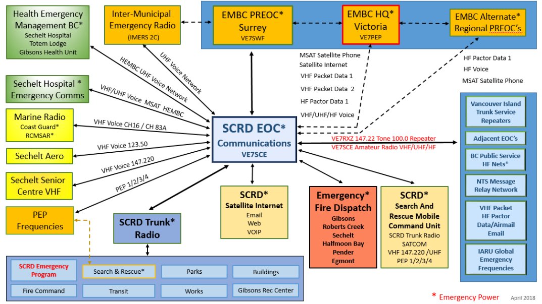
| SCRD Trunk Radio | Installed on Buses/SCRD Service & Parks Vehicles. Repeater on Mt. Benson & VE7RXZ as SCA 147.220 MHz is programmed into all SCRD Trunk radio SCEP 6 is the dedicated Emergency Program channel |
- Inter-Municipal Emergency Radio System via Bowen Island 2C repeater
- Health Emergency Management BC - Emergency Radio to VGH and Sechelt Hospital
- Emergency Fire Dispatch system for Sunshine Coast Fire Departments
- Marine and Aero Radio
Contact Information
Sources: EMBC, PERCS SWR, PERCS VIR
- SCEP:
- Callsign: VE7SCE
- 1975 Field Road, Sechelt (entrance on Solar Road)
- Tel: 604-885-6887
- email: emergency.program@scrd.ca
- Winlink: ve7sce@winlink.org
- EMBC South West Region (our region)
- Callsign: VE7SWF
- 14292 Green Timbers Way, Surrey, B.C. V3T 0J4
- Tel: 604-586-4390
- Fax: 604-586-4334
- email: EMBC.SWEAdmin@gov.bc.ca
- Winlink: ve7swf@winlink.org
- EMBC Vancouver Island Region (for reference only)
- Callsign: VE7PEP
- Block A - Suite 200, 2261 Keating Cross Road, Saanichton B.C., V8M 2A5
- Tel: 250-952-5571 or 250-952-5572 (old?: 250-952-5848)
- Fax: 250-952-4304
- email: EMBC.VIRAdmin@gov.bc.ca
- Winlink: ve7pep@winlink.org
Emergency Preparedness
Sources: PreparedBC, getprepared.gc.ca
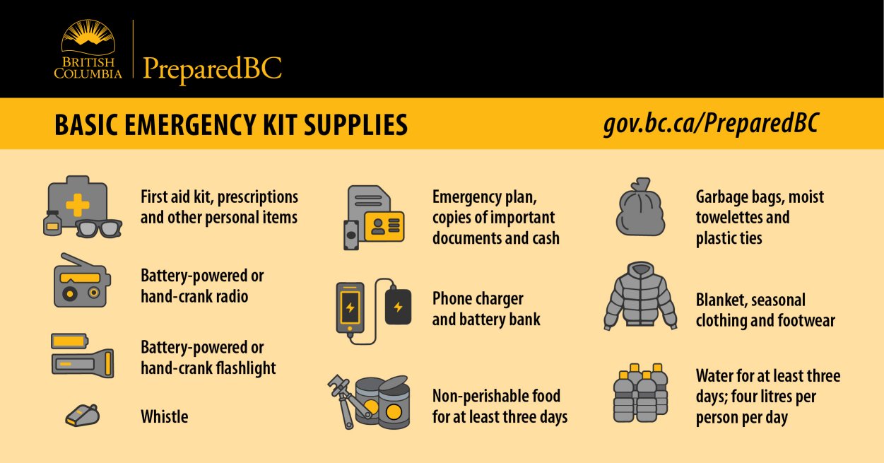
Basic emergency kit
- Water: At least two litres of water per person per day; include small bottles that can be carried easily in case of an evacuation order
- Food that won't spoil, such as canned food, energy bars and dried foods (replace food and water once a year)
- Manual can-opener
- Crank or battery-powered flashlight (and extra batteries). Replace batteries once a year.
- Crank, battery-powered radio (and extra batteries) or Weatheradio
- First aid kit
- Extra keys to your car and house
- Some cash in smaller bills, such as $10 bills and change for payphones
- A copy of your emergency plan and contact information
- If applicable, other items such as prescription medication, infant formula, equipment for people with disabilities, or food, water and medication for your pets or service animal (personalize according to your needs)
Recommended additional items
- Two additional litres of water per person per day for cooking and cleaning
- Candles and matches or lighter (place candles in deep, sturdy containers and do not burn unattended)
- Change of clothing and footwear for each household member
- Sleeping bag or warm blanket for each household member
- Toiletries
- Hand sanitizer
- Utensils
- Garbage bags
- Toilet paper
- Water purifying tablets
- Basic tools (hammer, pliers, wrench, screwdrivers, work gloves, dust mask, pocket knife)
- A whistle (in case you need to attract attention)
- Duct tape (to tape up windows, doors, air vents, etc.)
